| |
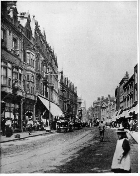
One of four cinemas in the town in the 1950s and '60s, the Gaumont, now the Gala Bingo
hall (right of centre above, left of centre below and detail right), was
showing the American musical "The I Don't Care Girl" when the picture
(below) was taken in 1953. The picture above shows the
section of the west side of Biggin Street leading up to Pencester Road and Worthington Street.
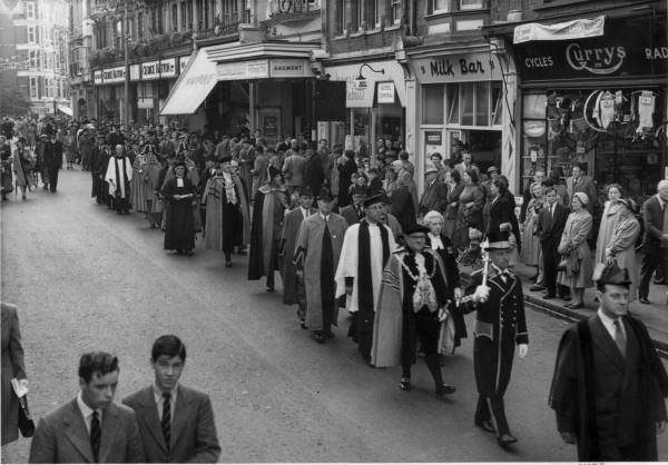
The picture below (from Lambert Weston, photographer, of Townwall Street)
shows a civic procession from St Mary's Church to the Town Hall, celebrating
the Coronation of Queen Elizabeth II.
|
 |
| |
Biggin Street 1953
(Picture courtesy of Dover Library)
|
| |
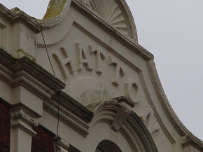
Between George Hatton Ltd. and the cinema is Maypole grocers - later the Top
Hat restaurant. Next to
the Gaumont cinema is a fabric shop - the name is partially obscured - and
the entrance to the Hotel Central. Nearer the camera is the Milk Bar
(open for snacks and Wall's ice cream) and Currys Ltd. (Cycles and Radios).
The latter would later move further down the road (see picture below) These properties (above and below) were built after the widening in 1896.
|
|
|
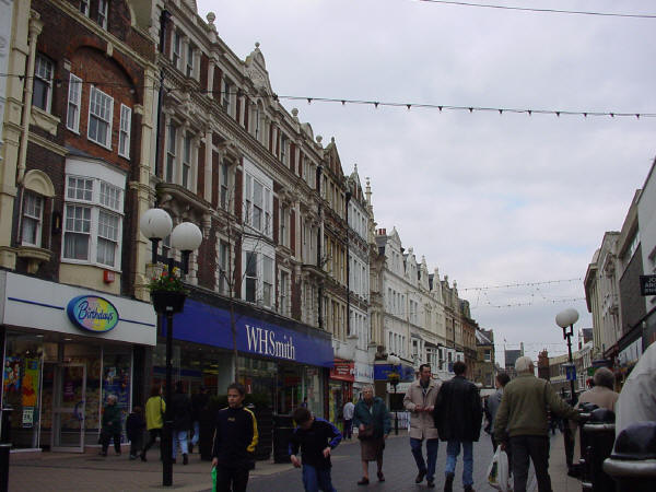
George Hatton's former department store in Biggin Street
now houses W. H. Smith's newsagent and book store.
In 1953, two-way traffic still flowed smoothly through
Cannon Street and Biggin Street to and from the Market Square (below).
|
| |

Biggin Street and Cannon Street
(Picture courtesy of Dover Library)
In the 1960s George Hatton occupied nos. 45, 46 & 47;
next to them at no. 44
we can see Currys. At no. 43 was Posner, a ladies' outfitter and
at no. 42, on the corner of New Street was Court's furniture shop.
On the other side we can see Dewhurst the butcher.
In front of the shop is a bus stop. The building adjoining the
Wellington Hotel has been demolished; the hotel would follow shortly
after.
|
| |
Biggin Street and St Mary's Church
(Picture courtesy of Dover Library)
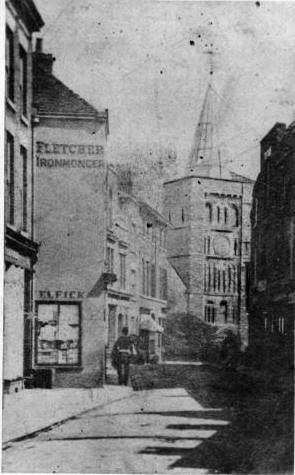
This much earlier view shows how narrow Biggin Street was at the point
where it met Cannon Street. |
33 Biggin Street
(Picture courtesy of Dover Library)
When this picture was taken of no. 33 Biggin Street,
Messrs. Marsh and Woolard, clockmakers, were "Selling Off, prior to
removal", presumably to make way for the widening of the road.
|
| |
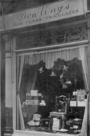
33 Biggin Street
(Picture courtesy of Dover Library)
When this picture was taken in the 1920s, no. 33 was a
High Class Chocolate shop.
|
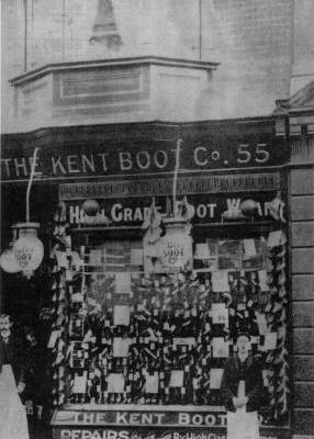
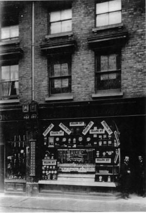
55 Biggin Street
(Picture courtesy of Dover Library)
At no. 55 was the Kent Boot Company - "High Grade Foot Ware" and repairs
by "High Class Craftsmen"
This picture was taken after the widening,
around 1905. |
| |
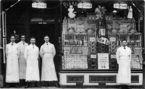
Pearks Grocers
(Picture courtesy of Dover Library)
This is Pearks the grocers - still in existence in the
1950s. Tea is offered at 1/4 (7p) and "double-weight
margarine" (what was that?) at 1/- (5p). "The key to our success is
quality".
This shop was formerly occupied by J.R. Geddes, boot and
shoe maker. It was later taken over by Curry's, purveyors of cycles
and radios.
|
| |
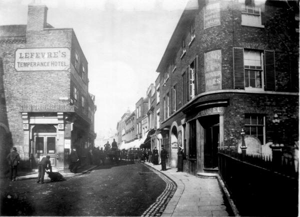
Biggin Street junction with Cannon Street and New Street
(Picture courtesy of Dover Library)
The buildings on the left of this picture were demolished
to widen the road in 1896. At this time, the Wellington Hotel was an
outlet of local brewers Leney & Co. The sign in the archway points
to the bowling green at the rear of the hotel. The building
adjoining is a library and a little further on can be seen the premises of
J. Doyle. On the right side of the road is a milk cart loaded with
churns; passing on the left is a wagon belonging to C.C. Rubie of Dover.
The basket in the back would suggest a bakery. Opposite the
Wellington, on the corner of New Street, is Lefevre's Temperance Hotel;
the Temperance Movement was gaining strength in the town at this time,
with regular meetings at Salem.
The reference to a bowling green is interesting, as the
Dover Bowling Club, which started in a corner of Pencester Gardens,
celebrates its centenary in 2007. This means that the green
pre-dated the club by over 10 years. The present-day green is in the
Maison Dieu Gardens.
"Before Biggin Street was widened, it was described
as 'an 18ft. lane,' and a miserable inadequate lane it was, considering
the great amount of traffic which pours through it during the busy hours
of the day."
"A census of the traffic, other than pedestrian, was
taken on the six working days of the last week in May, 1893, when it
transpired that there passed through Biggin Street, 9440 ordinary light
and heavy vehicles, 908 cycles and bath chairs, and 446 horses, making a
total of 10,794. The whole of these passed through the narrowest
part of the street, and 6749 continued their journey up past the Maison
Dieu, the remaining 4045 turning up the Folkestone Road. This
probably would not have caused a congestion of the traffic if it had
been distributed evenly through the twelve hours, but a large proportion
was crowded into two hours. The thoroughfare was so narrow that at
some points even a hand-barrow standing in front of a shop would stop
the traffic, and a goods van loading or unloading would so obstruct,
that a line of vehicles would soon be standing all up the street.
Viewed from the pavement in front of St. Mary's churchyard, the entrance
to Biggin Street seemed very narrow; the sidewalks were cramped, and
proceeding upwards, the frontage bent forward, so that about half way
between New Street and Pencester Road, there was, notwithstanding the
narrowness of the footpaths, barely room for two vehicles to pass, the
presence of a third always causing a block. This was considered a
sufficient justification for a widening scheme, and the street apart
from its narrowness, was, on the western side, dilapidated and out of
date." (JBJ 1907)
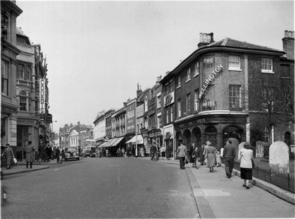
Biggin Street junction with Cannon Street and New Street
(Picture courtesy of Dover Library)
The Wellington Hotel on the right (Fremlin's Ales - Kent's
Best), adjoining St Mary's churchyard, was demolished in the early 1970s
to make way for the extension of Tesco's supermarket. Next door is Zip. The name of
the next shop is unclear, but next to that is Scott's (Dover's Dyers &
Cleaners since 1882). John Angell occupied the next shop for many
years, offering "Watch, Clock and Jewellery Repairs." "Let Burton
Dress You," announces the banner above the next shop - "Temporary
Premises." The next four shops cannot be identified from the
picture, but Marks & Spencer are clearly visible in their present premises
(nos. 28-30) with Murdoch (radio and pianos - no. 27) on the corner of Pencester Road. The
Midland Bank can just be made out on the opposite corner (nos. 26 & 26), but it is not possible
to identify any further. On the left, on the corner of New Street,
is Court's furnishers. On the opposite corner, closest to the
camera, is another Fremlin's house, but the name is not visible in this
picture.
|
| |
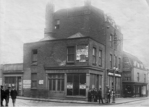
Biggin Street junction with Priory Street
(Picture courtesy of Dover Library)
When the picture (above) was taken, this building, on the
corner of Priory Street, had just been acquired by H.M. Postmaster General
for building the new Post Office. This in turn was demolished in the
1990s to provide a new Woolworth store.
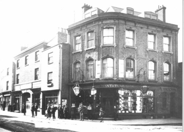
Biggin Street Junction with Priory Street
(Picture courtesy of Dover Library)
Looking in the other direction we can see the shoe shop of
Marchant & Tubb on the opposite corner (above).
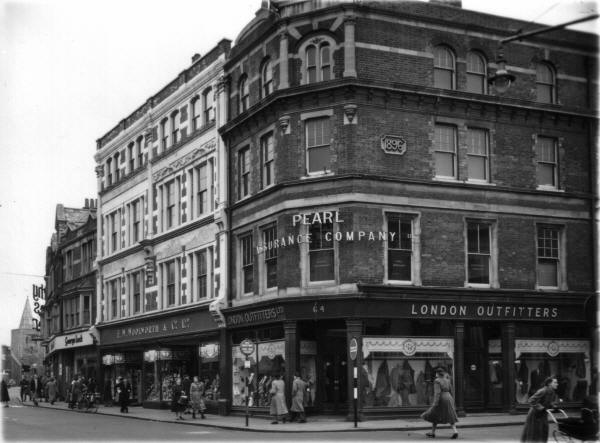
The picture below shows the same view in the 1950s, with
the London Outfitters occupying the corner spot. The Pearl Assurance
Company have their offices above the shop; they would later move to the
Market Square. F.W. Woolworth now occupies a large section of the
block. They later tried to purchase the whole block between
Worthington Street, Priory Street, Biggin Street and Priory Place, but
several businesses held out and Woolworth closed their Dover branch, not
re-opening until they acquired the old Post Office building on the
opposite corner of Priory Road.
Biggin Street Junction with Priory Street
(Picture courtesy of Dover Library)
Next to Woolworth's is George Lock, gents' outfitter, who
supplied the uniforms for most of the local schools. On the corner
the large sign announces Timothy White's and Taylor, chemist. The
shop in between is at an angle to the camera and the name cannot be
distinguished.
|
| |
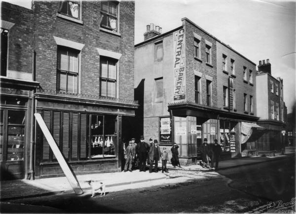
Biggin Street junction with Worthington's Lane c.1890
(Picture courtesy of Dover Library)
Worthington's Lane, now Worthington Street, was once a
very narrow thoroughfare, as can be seen from the picture above. On
the left is the butcher's shop of C.M. Woode and on the right, Holmes
Morris Central Bakery. The posters on the windows of the bakery
refer to the re-building, indicating that this picture was taken just
before the widening of the road.
|
| |

Biggin Street in 1953
(Picture courtesy of Dover Library)
This is the area of Biggin Street between Pencester Road
and Edward Road. Jack Williams the tobacconist is on the right,
followed by Holmes Morris and Playfair Shoes. Next along is the
World's Stores and the Salem Baptist Church. Moving along we find
Dewhurst the butcher and the Queen's Head public house, a Fremlins house.
These last three were demolished in the 1970s to make way for a new Boots
Chemist, which moved from its long-established position across the road on
the corner of Worthington Street. |
| |
|
| |
 |
|
The picture above shows the end of Biggin Street, near the Maison Dieu.
Most of the section between Pencester Road and Maison Dieu House has been
demolished and re-built in recent years.
|