|
Dover Index ... |
Dover Castle: lock and key of the Kingdom
|
|
LINKS
Constables |
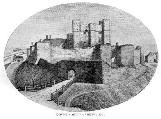
(Picture courtesy of Dover Library)
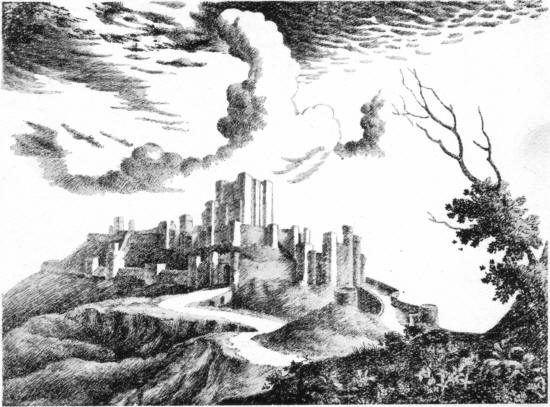
The town of Dover is often referred to as "The Gateway of
England" and the castle has long been known as "The lock and key to the
Kingdom" (Matthew Paris, 13c., "clavis et repagulum totius
Regni"). The engraving above is a somewhat fanciful representation of
what the castle would have looked like in 1200 A.D. Notice that there
are two entrances shown. Dover Castle is one of the oldest
and most important castles in the United Kingdom and one of the finest
examples of medieval fortifications in Western Europe. It is also one
of the few castles to have been almost continuously garrisoned well into the
20th century. The last troops to be stationed in the castle, the 1st
Bn, The Queen's Own Cameron Highlanders, moved across the road to Connaught
Barracks in October
1958, the accommodation in the castle being no longer considered suitable for modern soldiers.
The castle was handed over to the Ministry of Works in 1963. It is now
maintained by
English
Heritage. Information about the Garrison from the 12th century
onwards may be found in Atherton,
2003. St Mary-in-Castro continued to serve as the battalion chapel for troops
stationed at Connaught Barracks until these, too, were
de-commissioned in April 2007. The Constable's Tower remains as the
residence of the Deputy Constable of Dover Castle, who is the senior
military officer for the district, although Dover is no longer a garrison
town after being home to a succession of regiments for over 1000 years.
One Inspector of Ancient Monuments, writing in 1961, commented:
"One of the few Roman lighthouses in the world,
one of the noblest Norman Keeps in the Kingdom; visible evidence of a famous
siege as far back in time as 1216, together with what are probably some of
the mines and countermines employed. Add to these Tudor coastal
defence work, extensive artillery works of the Napoleonic period and the
mid-19th century, and the war room from which Admiral Ramsay controlled the
evacuation of Dunkirk, and it is clear that no other ancient monument in the
country can equal ... the breadth and scale of the historical compendium
that is compressed within 75 acres at Dover." (G.M.A. 2003)
|
|
"Dover Castle presents to the sea and land a striking symbol of
British power. The position it occupies has been a place of arms
since the time of the Roman occupation; yet, in spite of the changes of
twenty centuries, these mounds and trenches, walls and towers have been
adapted to the varying methods of warfare; and to-day, with the great
harbour for the Imperial Navy in front, and its fortified surrounding
heights, the old fortress is still associated with the defences of the
Empire." (J.B.J. 1916)
The hills on either side of Dover
bay have been used as a defensive stronghold since before the arrival of the
Romans; there is believed to have been an Iron Age hill fort on the cliff
top and the Britons would have occupied them with arms to repel Julius
Caesar in 55 BC. It may be that the caves in the cliff under the
castle are the work of these ancient warriors.
The first buildings on the
hills above the bay were probably of Roman origin, although they cannot be
accurately dated. It is likely that Julius Caesar, after his second
expedition in 54 BC, fortified the hills to protect the haven, which was
then the only sheltered harbour in Kent. The Pharos and other Roman
works probably date to around 49 AD, in the reign of Claudius Caesar.
"The chief Roman fortification was an oval-shaped plateau, measuring
400ft. from north to south and 140ft. from east to west. Around this
was dug a deep ditch, the chalk from which was thrown up to form a
rampart. Across the southern end of this oval were built, at a later
date, two towers. The western structure, to which the greater
antiquity is attached, is known as the Roman Pharos. The foundations
of this tower are laid in strong clay, a method adopted by Roman builders;
and experts state that the materials of the structure are Roman tiles,
Roman mortar, and tufa, a substance that the Romans invariably used when
they could procure it. There was plenty of tufa to be found in the
valley of the Dour; but there was no building stone on the spot.
The foundations of a similar tower, presumably built at the same period,
were found on the Western Heights. It is supposed that both these
towers were raised in order to support beacon fires, to guide mariners in
entering Dover haven. On the eastern side of the oval plateau, in
the Castle, was built another tower, to be used as a specula or look-out.
This tower now forms the central portion of the church of St.
Mary-in-the-Castle, it being supposed that the chancel, nave, and
transepts were added, some centuries later, to transform the watch tower
into a Christian church." (J.B.J. 1907)
 |
|
|
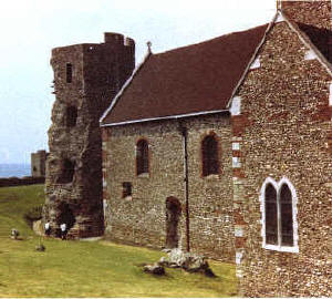
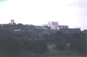
This picture shows the Saxon church of St. Mary in Castro and the Roman
pharos.
There has been speculation that the original church building was erected by
Lucius in 180 AD. The country later lapsed into heathenism and the
church fell into disrepair until being restored by King Eadbald, who founded
a college of six canons in connection with it, quartered in Colton Gate.
This can not been substantiated, but the church is clearly of very ancient
origin. |
|
|
|
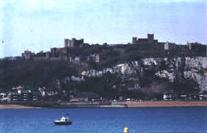
From the cliff road to St Margaret's
This view is taken from the road which runs along the cliffs from the
back of the castle to St. Margaret's at Cliffe.
|
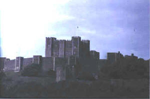
From the Pier
This view is from the end of the Prince of Wales' Pier. The church of St. Mary in
Castro, the Pharos and the Sergeants' Mess from the 19th century barracks can be clearly seen to the right of the main
castle buildings.
|
"During the six centuries of Saxon rule, the earthworks of the
Castle were extended, and strengthened by the erection of towers and
walls. Having encased the southern part of the Roman oval with
masonry, on the western side of that wall they built a continuation called
the Saxon Curtain, connecting the Roman work with the Colton tower, which,
during the Saxon period, formed the entrance to the Castle. King
Eadbald, about the year A.D. 620, continued the wall, in a westerly
direction, to the slope of the hill, and then, turning at a right angle
northward, continued to a point opposite the present Norman Keep, and
within the angle thus enclosed (the present drill ground) were built the
houses of King Eadbald's canons, who, later, were transferred by King
Withred to St. Martin-le-Grand, in the Market Place.
On the eastern side of the Roman oval, the Saxons, not long before
the Conquest, built Godwin's tower and other strong works from which a
gallery led to a postern opening into King's Bottom, now known as the
Northfall Meadow." (J.B.J. 1907)
|
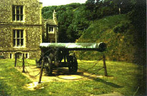
Queen Elizabeth's Pocket Pistol
This cannon is affectionately known as Queen Elizabeth's
Pocket Pistol.
|
From the sea front
This picture was taken from the sea front using a long lens.
|
|
Earl Godwin was the custodian of
the Castle and was succeeded by his son Harold who, during the reign of
Edward the Confessor, built a wall of irregular shape between Godwin's tower
and Colton tower, in which were included four further towers. One of
these was the Well tower, which contained a well drawing pure water from a
depth of about 250ft.
Northwards of this wall was the Saxon keep, which
occupied the same position as the present keep yard, but was then only a
plateau, enclosed on the western side by an earth rampart but having, on the
north-east, a strong Saxon gateway known as the King's gate, which still
exists.
|
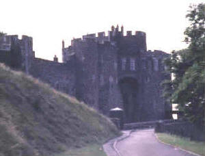
Constable's Tower
|
Constable's Tower is now the main pedestrian
entrance to the castle. There is a bridge across the moat where once
there was a drawbridge. The dungeons open into the bottom of the moat
to the left of the tower.
"The Constable's Tower is in the outer ward ... It is one of
the finest gateways in England, and tradition says it was built by John de
Fiennes, who was appointed Constable during the life of William the
Conqueror." (J.B.J. 1907)
|
"The first great Norman work was the building of the Keep, and the
walls enclosing the Keep yard. This was commenced about the year
1168, and finished in 1188, the greater part of the work having been done
between 1181 and 1188..."
"... The Norman Keep, for which we are indebted to Henry II. and is
master builders, Fitz-Helto and Enemenda, stands 343ft. above sea level,
the altitude of the highest turret being 469ft. This Keep, with the
walls and towers surrounding it, forms the inner ward of the Castle,
approached by two gates - King's gate on the north-east, and Palace gate
on the south. The middle ward, now imperfect, consisted of the Roman
and Saxon works; and the outer ward, still complete, consists of the outer
wall, which encloses the whole hilltop, around which there are 27 towers.
Some of the towers in the outer ward existed from the early part of the
Norman period; but the completion of the wall and towers of the outer ward
was the work of Hubert de Burgh, between the years 1220 and 1239, after
the unsuccessful siege by the Dauphin of France."
(J.B.J. 1907)
|
|
|
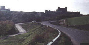
This picture was taken from the cliffs behind the castle, looking over the old parade
ground.
Where the married quarters and parade ground used to be, the Jubilee Way bypass now
cuts through the cliffs joining the Eastern Docks to the main A2 road to London.
|
From the meadow
|
|
|
"In dramatic interest and moving incidents, the history of Dover
Castle surpasses that of any other fortress in Britain. Through this
gate of the realm a never-ceasing stream of the great and the notable have
been passing ever since mankind began to move to and fro on the face of
the earth, and to their upturned eyes this castle has been the first
object of interest." (J.B.J. 1916)
|
|
|
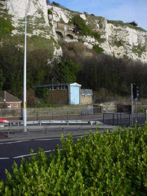
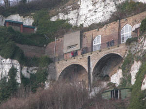
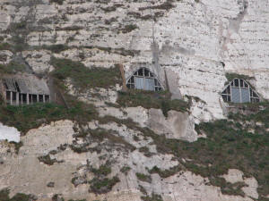
The cliffs under the Castle are honeycombed with tunnels, some dating
from Tudor times and others from WW2.
The brick-built arches in the picture on the right are part of the
Casemate Barracks, built between 1793 and 1801 (picture below, left).
It was from this terrace in the cliff face that Winston Churchill would
look out over the Channel to the French coast.
The tunnels behind were a military hospital and command centre. In
the Cold War, they were converted into a government shelter in case of a
nuclear attack (picture below, right).
The observation platform on the top of the cliff is the Port War Signal
Station and Admiralty Lookout, left over from WW2.
At the base of the cliffs the boat-house stands near the site of the old Guilford Battery and to the
left, just out of the picture, are the remains of Mote's Bulwark, built by
Henry VIII c.1540. |
 |
|
|
 |
 |
|
|
Some of the tunnels have been opened to the public in recent years,
including the terrace of the Casemate Barracks, as can be seen in the
picture above. The lower level, however, known as Dumpy, which was to
have been the centre of regional government in the event of a nuclear
attack, is still closed. |